The Tornado That Left a Scar on the Northwoods
- Northeast Wisconsin Weather

- Jun 16, 2021
- 2 min read
JUNE 7, 2007 - By June 2, 2007, the Storm Prediction Center (SPC) had this event already on their radar, issuing a severe threat in their Days 4-8 outlook, which notes that a severe threat is likely. On subsequent updates, the Storm Prediction Center increased their confidence in this event and by June 5, 2007 (3 days before this event), they issued a Moderate Risk for severe thunderstorms.
NOTE: At this point, the SPC only had 4 outlook categories; General T-Storms, Slight, Moderate, and High risks. It wasn't until 2014 that they added 2 more to have a total of 6; General T-Storms, Marginal, Slight, Enhanced, Moderate, and High.

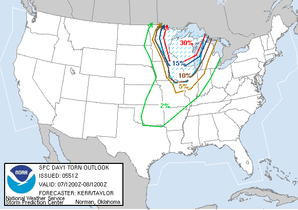
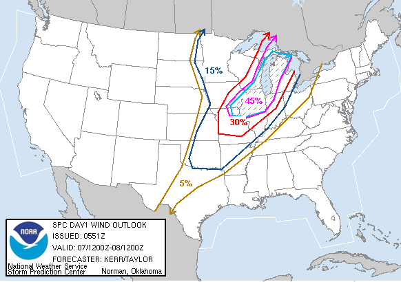
In the 600 UTC (1AM) update, the Storm Prediction Center placed all of Northeast Wisconsin under a High Risk (Level 3/3). In this update, they noted:
[THE] POTENTIAL FOR TORNADIC SUPERCELLS SEEMS HIGH. A FEW STRONG TORNADOES ARE POSSIBLE AS CONVECTIVE ACTIVITY DEVELOPS
Along with the High risk, they put Northeast Wisconsin under a 30% hatched tornado probability (30% chance of a tornado with a 10%+ chance of an EF2-EF5), 30-45% hatched damaging wind probability (30-45% chance of severe damaging winds with a 10%+ chance of 75+MPH winds, and a 45% chance of severe hail (1"+).

At 11:35 AM the Storm Prediction Center issued a PDS (Particularly Dangerous Situation) Tornado Watch for our most western counties. The watch was for:
DESTRUCTIVE TORNADOES...LARGE HAIL TO 2.5 INCHES IN DIAMETER... THUNDERSTORM WIND GUSTS TO 80 MPH...AND DANGEROUS LIGHTNING ARE POSSIBLE IN THESE AREAS.
Then, at 2:40 PM the Storm Prediction Center issued a PDS (Particularly Dangerous Situation) Tornado Watch for the rest of Northeast Wisconsin. They again noted the potential for destructive tornadoes, large hail, damaging wind gusts and dangerous lightning.

THE OUTCOME:
Fast-moving supercell thunderstorms will "gorilla" size hail (around 5" in diameter) moved through Northeast Wisconsin. There was a total of 5 tornadoes that touched down. I will be breaking each one of those down.
The most destructive tornado touched down at around 4:31 PM east of Mattoon (Shawano County), according to the National Weather Service in Green Bay. This tornado would be on the ground for around 40 miles, traveling through Shawano, Oconto, Menominee and Marinette counties. This tornado was estimated to be 1/2 mile wide at times, destroying over 140,000 acres of trees were snapped and flattened, in addition to numerous houses and buildings. This was rated an EF3 with winds estimated between 140-160 MPH, according to the NWS survey. This tornado caused an estimated $15 million in damage, including damage to property and timber. Today, the "scar" is still seen today from space.


An EF2 tornado ripped through Marathon County near Mosinee. This tornado caused an estimated $350,000 in damage. There were 3 other tornadoes, rated either an EF0 or EF1 that caused minimal damage.
The other part of this event was the massive hail that fell with these storms. In Wood County in particular, hail of 5.5" in diameter was recorded.

This day will forever be in the record books and thankfully, no lives were lost.
SOURCES:
Storm Prediction Center (www.spc.noaa.gov)
National Weather Service Green Bay (https://www.weather.gov/grb/060707_tornadoes)


Comments